Los Alamos, New Mexico
| Los Alamos, New Mexico | |
|---|---|
| — CDP — | |
 |
|
 |
|
| Coordinates: | |
| Country | United States |
| State | New Mexico |
| County | Los Alamos |
| Area | |
| - Total | 10.9 sq mi (28.1 km2) |
| - Land | 10.9 sq mi (28.1 km2) |
| - Water | 0.0 sq mi (0.0 km2) |
| Elevation | 7,320 ft (2,231 m) |
| Population (2000) | |
| - Total | 11,909 |
| - Density | 1,096.2/sq mi (423.2/km2) |
| Time zone | Mountain (MST) (UTC-7) |
| - Summer (DST) | MDT (UTC-6) |
| ZIP codes | 87544-87545 |
| Area code(s) | 505 |
| FIPS code | 35-42320 |
| GNIS feature ID | 0901357 |


Los Alamos (Spanish: Los Álamos, meaning "The poplars") is a townsite and census-designated place (CDP) in Los Alamos County, New Mexico, United States. The population of the CDP was 11,909 at the 2000 census. The townsite or "the hill" is one part of town while White Rock is also part of the town. Technically, both are part of the same incorporated city/county. Los Alamos is home to the Los Alamos National Laboratory, which was founded to undertake the Manhattan Project. Los Alamos County is an incorporated county, and many county offices are located at the townsite of Los Alamos. Los Alamos High School is the public high school of Los Alamos County. Before the Manhattan Project, the site was occupied by the Los Alamos Ranch School. Los Alamos has a county council which the people elect to four-year terms. The county council is seven members with four or three persons elected every two years to the four-year terms. The council elects a chairman and vice-chairman.
Contents |
History
Los Alamos was founded as a secret planned community to provide housing for the employees of the Manhattan Project during World War II. Although locals were aware of its existence, all information about the town was highly classified until the bombing of Hiroshima, and any outbound correspondence by those working and living in Los Alamos was censored by military officials. At the time, it was referred to as "The Hill" by many in Santa Fe, and as "Site Y" by military personnel.
Geography
Los Alamos is located at (35.891086, -106.297727),[1] approximately 35 miles (56 km) to the northwest of Santa Fe. Elevation is 7320 feet.
According to the United States Census Bureau, the CDP has a total area of 10.9 square miles (28 km2), all of it land.
Demographics
As of the census[2] of 2000, there were 11,909 people, 5,110 households, and 3,372 families residing in the CDP. The population density was 1,096.2 inhabitants per square mile (423.2 /km2). There were 5,463 housing units at an average density of 502.8 per square mile (194.1 /km2). The racial makeup of the CDP was 89.13% White, 0.44% African American, 0.56% Native American, 4.47% Asian, 0.04% Pacific Islander, 3.01% from other races, and 2.35% from two or more races. Hispanic or Latino of any race were 12.21% of the population.
Los Alamos is New Mexico's best educated community, proportionately, with 68.6% of adult residents (25 and older) holding an associate degree or higher, and 62.1% of adults possessing a bachelor's degree or higher (2000 Census).
There were 5,110 households out of which 31.4% had children under the age of 18 living with them, 56.4% were married couples living together, 6.5% had a female householder with no husband present, and 34.0% were non-families. 29.8% of all households were made up of individuals and 7.6% had someone living alone who was 65 years of age or older. The average household size was 2.31 and the average family size was 2.89.
In the CDP the population was spread out with 24.8% under the age of 18, 4.8% from 18 to 24, 29.2% from 25 to 44, 28.2% from 45 to 64, and 12.9% who were 65 years of age or older. The median age was 40 years. For every 100 females there were 101.3 males. For every 100 females age 18 and over, there were 100.1 males.
The median income for a household in the CDP was $71,536, and the median income for a family was $86,876. Males had a median income of $65,638 versus $39,352 for females. The per capita income for the CDP was $34,240. About 2.4% of families and 3.6% of the population were below the poverty line, including 2.6% of those under age 18 and 5.3% of those age 65 or over.
The home ownership rate (owner-occupied housing units to total units) is 71.5%. After the Manhattan Project, the first sale of a private home in Los Alamos was made in 1965 by the US Government to William Overton, who bought a house on Manhattan Loop.[3]
VLBA node
The radio telescope located in Los Alamos is one of ten dishes composing the Very Long Baseline Array (VLBA).
City and regional partnership
Los Alamos maintains a sister city status with the following international location:
| City | Country | Sister City since |
|---|---|---|
| Sarov | 1993 |
Wildfires

- 1954 Water Canyon Fire
- 1977 La Mesa Fire
- 1996 Dome Fire
- 1998 Oso Complex Fire
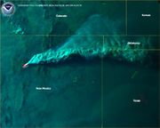
- 2000 Cerro Grande Fire
See also
- Ed Grothus
- Casa Mesita
- Info Mesa
References
- ↑ "US Gazetteer files: 2000 and 1990". United States Census Bureau. 2005-05-03. http://www.census.gov/geo/www/gazetteer/gazette.html. Retrieved 2008-01-31.
- ↑ "American FactFinder". United States Census Bureau. http://factfinder.census.gov. Retrieved 2008-01-31.
- ↑ LANL Newsletter 5(24):7, week of November 22, 2004
External links
- Los Alamos County website
- Los Alamos, NM at the Open Directory Project
- h2g2 article on Los Alamos, New Mexico
- Online Visitor Guide to Los Alamos
- Los Alamos travel guide from Wikitravel
- Los Alamos-Sarov Sister Cities website
|
|||||||||||
|
|||||||||||||||||
